Comment on the BLMs Plan for Bristol Bay
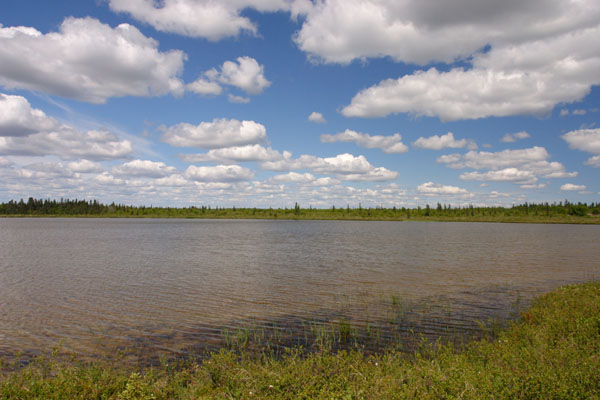
2302 - Tundra lake under puffy clouds on BLM land along the lower Kvichak River.
Comments on the Draft Plan are Due February 5, 2007
Read below for a brief summeary of the plan, my letter to the BLM, and email/snail mail addresses for comments
The Pebble Mine project is a controversial proposal by Northern Dynasty Minerals to build one of the largest gold and copper mines in the world, in southwest Alaska, near Lake Iliamna. Northern Dynasty has not yet applied for permits, but their current proposal involves both a large open pit and an underground mine, as well as removal of the water from the headwaters of Upper Talarik Creek and the Koktuli River ( important fish habitats). The site sits at the headwaters of two major Bristol Bay drainages ( Nushagak and Kvichak), and potentially poses a large threat to the region's salmon. This proposal has become a major political issue in Alaska, pitting pro-mining forces against local native villages and commercial and sport fishermen.
This plan covers about 3 million acres of land in Southwest Alaska.
Most of this is in the Bristol Bay watershed - in the drainages of the Kvichak and Nushagak Rivers.
The rest is farther west in the Goodnews Bay area.
Currently most of this land is closed to mining and oil drilling, much of it due to unresolved Alaska Native Claims Settlement Act (ANSCA 17 d 1) withdwawls, and the BLMs plan is to open it up.
To read details of the plan, get the pdf on the BLMs website
Alternatives
The BLM has proposed four alternative plans for its land in the area.
Alternative A
Alternative A is the "no action" plan.
Land that is withdrawn and currently closed to mining exploration and oil drilling will remain withdrawn and closed.
Alternative B
Alternative B is the "resource extraction" plan.
Basically all the land will be open for mining and oil drilling with no special restrictions or constraints.
Alternative C
Alternative C is the "renewable resource" plan.
Basically all of the land will be open to mining and oil drilling, with some seasonal restrictions on oil drilling.
Two Areas of Critical Environmental Concern will be designated - in Bristol Bay and Carter Spit, but drilling and mining will still be allowed within them.
The only thing excluded from these areas will be gravel mining.
Alternative D
Alternative D is the "balanced plan"
Basically all the land will be open to mining and oil drilling.
An Area of Critical Environmental Concern (ACEC) will be designated on Carter spit, but drilling and mining will still be allowed within it.
The only thing excluded from this area will be gravel mining.
For a more detailed summary, see the actual plan
The BLMs preferred plan is Alternative D.
In my opinion, plans B, C, and D are all quite similar, and quite inadequate.
Read my suggested letter to the BLM below, or download it here: BLM letter.
But whether or not you agree with me, please tell the BLM what you think!
Comments are due February 5
and can be sent to
Bureau of Land Management
Anchorage Field Office
Attn: Bay Draft RMP/EIS
6881 Abbott Loop Road
Anchorage, Alaska 99507
Mark Fullmer, NEPA Coordinator
Phone: (907) 267-1264
Email: akbayrmp@blm.gov
Bureau of Land Management,
I am writing in response to the Draft Management Plan and Environmental Impact Statement put out for the Bristol Bay and Goodnews Bay regions.
The current preferred alternative (Alternative D) does far too little to protect the extraordinary ecological values of the Bristol Bay region. The Bristol Bay watershed is one of the world's most productive salmon spawning grounds. Much of the BLM's land holdings in the area lie on salmon spawning streams, near major salmon-bearing rivers (the Nushagak and the Kvichak).
Despite this, not a single Area of Critical Environmental Concern (ACEC) is designated in the Bristol Bay watershed. The only ACEC - on Carter Spit, allows both oil and gas drilling and hardrock mining to occur in the area.
This proposal opens virtually the entire region to hard rock mining and oil and gas drilling. These industries have a high potential for creating pollution, and could significantly endanger the wildlife and renewable resources in the area. Hard rock mining, in particular, poses a very high risk to the water quality necessary for the region's abundant salmon runs. According to the EPA, it has polluted 40% of western watersheds in the continental U.S.
Alternative D is prresented as a "balanced" plan, balancing ecological values and resource extraction. This "balance" allows mining and drilling on over a million acres of pristine wilderness, while doing almost nothing to protect ecological values or extraction of the region's renewable resources, such as salmon.
Fish and mineral extraction do not go together - the Bristol Bay watershed should not be open to hard rock mining.
The Bristol Bay watershed is an Area of Critical Environmental Concern. I urge you to designate it as one and take steps to protect its values - by prohibiting oil and gas drilling and hard rock mining within this critical salmon habitat.
Sincerely,
Erin McKittrick
Read the guestbook | Sign the guestbook
All content by Erin McKittrick, copyright 2006-2007. Contact me with comments or questions at mckittre at gmail dot com.
Go to Alaska Trekking home. Go to Ground Truth Trekking home.
Last modified: 2/11/2007